Friday, March 30, 2007

3 blogs for one


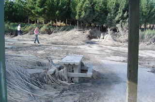
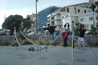
Today you get three blogs for one. This blog site only allows 5 pictures per blog entry but we have 14 so the two blogs below this are new as well. Here's some non LOTR stuff. (1) Recent damage from the lahar (volcanic mudslide) you may have heard of. (2) A funky fixed-rail-skate thingy in a Wellington park. Off to the right is our cousin's cousin David DuBois who showed us around and gave us the lowdown on Wellington. A fairly animated guy as you can tell. (3) A week or so ago we did the Tongariro Crossing hike. Here's a “Where's Betsy” shot on the "devils staircase" which is an hour of climbing up chunky lava. (4) A postcard-like shot of Ketetahi creek at the end of the hike.
Now we're on the south island. Here's a shot of Queen Charlotte Sound (5) which the ferry goes through to get to the port. Somehow we got through 5 weeks of the North Island with only a couple days of rain, so here we’re finally getting some real New Zealand weather. We’re going to talk to someone about this.


On the way down towards Wellington, we passed a good deal more LOTR sites. Most likely due to Peter Jackson and his studios being based in Wellington. So the next blog or two will be LOTR heavy again. The thing that surprises us the most is how some of the sites are so close to houses or roads but all they used was the one angle that didn't have any of those things in them (or had them digitally removed). (1) The falls at Ithilien where Gollum was caught. (2) A spot near the falls that was used for some shots near Ithilien. (3) Dunharrow- camp where the riders of Rohan met before going to Minas Tirith. (4) Turn 180 degrees and this is the view of Wellington. Not a lot of space to work with. Wide shots and backgrounds were sometimes taken somewhere else and blended together for a lot of scenes.

More LOTR


More LOTR sites: (1) and (2) One of the 4 NZ rivers used to portray the Anduin in wide shots as the fellowship floats downstream. A couple shots (3) and (4) of places in a Wellington park where the paths were used for the hobbits in "leaving the shire". And the infamous "root" spot (5) where the hobbits hid from the nazgul. The oversized roots were fake and taken away after shooting but the spot is unmistakable as there are signs to it and thousands of tourists have trampled the place. And the guide book I bought has GPS coordinates for some of the places.

Friday, March 23, 2007

Mordor (part 2)


See part 1 below since I'm posting these 2 blogs simultaneously.
Here are 3 pictures of "Mt Doom" aka Mt. Ngauruhoe.
(1) Mt Doom and the plains before it without the orc armies.
(2) Zoom in of the same picture with a small lake in front.
(3) Blake and his Precious laughing at the folly of Sauron.

Visit to Mordor


Nerd Alert! The following blog references Lord of The Rings.
A good number of scenes for Mordor were shot in Tongariro National Park. We could have
sported $250 per person to take a LOTR tour. Instead we used various reference sources
to try and piece together all the locations we could on our own for free. So take the
following assertions with a grain of salt since we have not seen the movies in a little
while. The pictures will be described in order. Also note that most scenes in the
movie have been bastardized quite a bit by CGI so original locations are often
hard to pick out. Of note, Mt Doom was made taller. The up-close shots
were not shot on the side of Mt Doom but on Mt Ruapehu next to it (easier access- a
4 star hotel is nearby).

(1) Believe it or not, to the left of the closest lodge is where a lot of up-close
Mordor shots were taken with the Hobbits.
(2) and (3) are inside this little valley which doubled as Emyn Muil and Mordor.
Behind this valley is a ridge and a huge canyon that looks kinda familiar so I'm
going to guess they may have used this (4) for the scenes where Frodo and Sam are climbing
into Mordor up that gnarly staircase.
(5) These Pinnacles are cool and probably aren't in the movie but if so, Nazgul would
be swooping through them.

Monday, March 19, 2007

Rafting


First of all, we were not on this trip but got good pics of this waterfall. It is the largest drop any commercial trip does world wide (21 feet) but is relatively safe since there's no rocks around. But the raft does completely go underwater. Look closely in the first picture- there's a yellow raft in there. Then it pops up in the second picture. Betsy hasn't rafted before so we'll pick something a little more tame her first time out.

The last picture is a cool place we stayed at with it's own little bay.

Wednesday, March 14, 2007

Filler blog


A couple more random pics. One from the Port Jackson road and
another from Cathedral Cove.

Monday, March 12, 2007

Black water cave rafting


Today we rappelled into a cave, zipped down a zip line, inner-tube rafted under glowworms (looks like stars at night on the ceiling of the cave), and spelunked out through some small caverns and waterfalls. We couldn't bring our own cameras so I can only show some pictures they took.

Saturday, March 10, 2007


Due to popular request, here's pics of the kauri tree, dunes and a Where's Betsy?

Sunday, March 4, 2007

Top of the island


Here's a couple views from Cape Reinga- the northernmost tip of the North Island. We're on our way back south, on the way we did a little sand boarding on some huge dunes and seen the largest Kauri tree. I think sequoias are bigger but it was a solid effort.